Trail Walking Le Dévoluy - Superdevoluy : tour de la Baume - Photo

Superdevoluy : tour de la Baume

 qlqin
qlqin

User

© OpenStreetMap contributors
Length
Length
7.5 km
Max alt
Max alt
1613 m
Uphill gradient
Uphill gradient
349 m
Km-Effort
Km-Effort  
12.2 km
Min alt
Min alt
1293 m
Downhill gradient
Downhill gradient
360 m
Boucle
Boucle
No
Creation date :
2023-08-10 08:21:29.393
Updated on :
2023-08-10 11:42:12.089

(0 Reviews)

Walking
Walking
2h16
Difficulty : Medium

Scan this QR Code to open this trail in the SityTrail application

FREE GPS app for hiking

Logo SityTrail SityTrail

IGN / Geographical institutes

Download SityTrail from the App Store Download SityTrail from Google Play

Logo SityTrail SityTrail World

The world is yours!

Download SityTrail from the App Store Download SityTrail from Google Play Download SityTrail on Huawei AppGallery

About

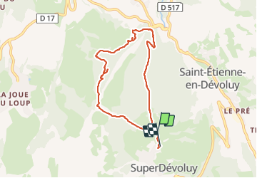
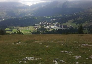
Trail Walking of 7.5 km to be discovered at Provence-Alpes-Côte d'Azur, Hautes-Alpes, Le Dévoluy. This trail is proposed by qlqin.

Description

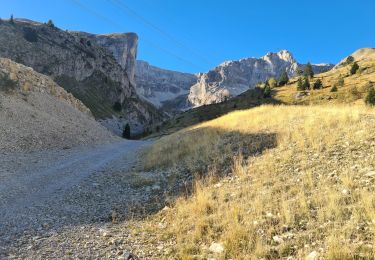
Tres jolie ballade en sous-bois, hormis la montée au Collet du Tât qui s'effectue dans la caillasse.
Attention : ne pas prendre le raccourci proposé par la carte IGN, car il n'existe plus.
Limite sportive (utilisée pour des traces de trails), l'ancienne trace IGN se perd au profit d'une descente pour les VTT, à 2 reprises. Mais finalement et heureusement le passage aux Etroits est atteint sans encombres 🤗.

Elevation profile

Positioning

Country:
France
Region :
Provence-Alpes-Côte d'Azur
Department/Province :
Hautes-Alpes
Municipality :
Le Dévoluy
Location:
Saint-Étienne-en-Dévoluy
Start:(UTM)
732052 ; 4951799 (31T) N.

Trails nearby

Trail Walking Le Dévoluy - R29   La crete des Beaumes - Photo
Walking
GUIDE+

Walking

Medium
(2)
Le Dévoluy, Provence-Alpes-Côte d'Azur, Hautes-Alpes, France
9 km | 16 km-effort
3h 17min
Yes
Trail Walking Le Dévoluy - R28   Le Col de Rabou - Photo
Walking
GUIDE+

Walking

Medium
(1)
Le Dévoluy, Provence-Alpes-Côte d'Azur, Hautes-Alpes, France
10.6 km | 17.9 km-effort
3h 52min
Yes
Trail Walking Le Dévoluy - R27   Les gorges du Rif - Photo
Walking
GUIDE+

Walking

Easy
(1)
Le Dévoluy, Provence-Alpes-Côte d'Azur, Hautes-Alpes, France
7.5 km | 11.5 km-effort
2h 27min
Yes
Trail Walking Le Dévoluy - Tour du Dévoluy - Superdévoluy à Lachaup - Photo
Walking
tracegps

Walking

Medium
(1)
Le Dévoluy, Provence-Alpes-Côte d'Azur, Hautes-Alpes, France
8.3 km | 12.5 km-effort
3h 0min
No
Trail Mountain bike Le Dévoluy - VTT31 - Col de Rabou - Photo
Mountain bike
GUIDE+

Mountain bike

Medium
Le Dévoluy, Provence-Alpes-Côte d'Azur, Hautes-Alpes, France
19.7 km | 31 km-effort
1h 55min
Yes
Trail Walking Le Dévoluy - R26   Le tour de la crête d'âne - Photo
Walking
GUIDE+

Walking

Medium
Le Dévoluy, Provence-Alpes-Côte d'Azur, Hautes-Alpes, France
10.5 km | 19.7 km-effort
3h 58min
Yes
Trail Walking Le Dévoluy - R21   L'observatoire de Bure depuis la Joue du Loup - Photo
Walking
GUIDE+

Walking

Difficult
Le Dévoluy, Provence-Alpes-Côte d'Azur, Hautes-Alpes, France
11.9 km | 21 km-effort
4h 21min
Yes
Trail Walking Le Dévoluy - crête des baumes - Photo
Walking
timothee60

Walking

Easy
(1)
Le Dévoluy, Provence-Alpes-Côte d'Azur, Hautes-Alpes, France
9.4 km | 14.1 km-effort
3h 11min
Yes
Trail Walking Le Dévoluy - pic de Bure - Photo
Walking
tchoua

Walking

Difficult
Le Dévoluy, Provence-Alpes-Côte d'Azur, Hautes-Alpes, France
16.6 km | 34 km-effort
4h 48min
Yes


Close
My subscriptions